CONTACT US:
Florida Fish and Wildlife
Conservation Commission
Fish and Wildlife
Research Institute
100 Eighth Avenue SE
St. Petersburg, Florida 33701
727-896-8626
|
|
|
Charlotte County
UF/IFAS Extension
Florida Sea Grant
25550 Harbor View Rd #3
Port Charlotte, Florida 33980
941-764-4340
|
|
|
|
|
Funding for this project was obtained through grants from the West Coast Inland Navigation District and Charlotte County.
|
|
|
Additional funding for this project was obtained through the Federal Aid in Sport Fish Restoration Fund.
|
|
|
 |
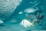
Artificial reefs are man-made habitats that serve to increase reef fish habitat and enhance fishing and diving opportunities. These man-made habitats vary from reef to reef. Some reefs are composed of concrete reefballs of varying sizes, bridge rubble, old boats and retired military hardware (cleaned in accordance with Florida law). Once deployed, marine life starts colonizing the new habitat. As the reef ages and gets encrusted with algae, barnacles, and corals, small fish colonize the reef, thus attracting larger predatory fish such as grouper and amberjack.
|
|
Below is a list of artificial reefs found on the printed Boating and Angling Guide to Charlotte Harbor. The number identifying each reef is the same as the identifying number used printed guide.
There are many more artificial reefs in the offshore waters of Sarasota (PDF), Charlotte (PDF), and Lee counties that are not listed here or shown on the boating guide. A complete listing of artificial reefs in these areas, as well as for the rest of Florida is available from the Artificial Reef Program within the FWC's Division of Marine Fisheries Management.
|
| No. Reef Name |
Description |
Depth (ft) |
Latitude
Longitude |
| 1. Englewood Fish Haven |
Bridge Rubble |
22 |
26° 54.700' N
82° 21.800' W |
| 2. Tremblay Reef (2 reefs) |
90' steel barge, concrete bridge rubble |
42 |
26° 48.350' N
82° 22.700' W |
| 3. Novak Reefs (8 reefs) |
Concrete culverts and concrete bridge sections |
30 |
26° 48.570' N
82° 19.700' W |
| 4. Mary's Reef (3 reefs) |
Concrete culverts |
29-30 |
26° 46.235' N
82° 18.430' W |
5. Gasparilla Mitigation Reef
(3 reefs) |
Rock limestone |
12 |
26° 45.325' N
82° 16.025' W |
| 6. Power Pole Reef |
Old power poles, crane, and steel barge |
45 |
26° 40.957' N
82° 22.470' W |
| 7. Danger Reef |
40' steel tug |
12 |
26° 45.554' N
82° 11.167' W |
| 8. Cape Haze Reef |
Concrete culverts, modular steel units |
18 |
26° 45.761' N
82° 09.494' W |
| 9. Bokeelia Reef |
Concrete culverts |
10 |
26° 43.038' N
82° 09.642' W |
10. Charlotte Harbor Site
(north coordinates) |
Concrete culverts and reefballs |
12 |
26° 51.502' N
82° 05.296' W |
10. Charlotte Harbor Site
(south coordinates) |
Concrete culverts and reefballs |
12 |
26° 50.600' N
82° 05.317' W |
If you have any questions, comments, or suggestions about this Web site, please e-mail us at Boating_Guides@MyFWC.com.
Would you like to receive notices of changes to this Web site and the Boating and Angling Guide to Charlotte Harbor? If so, please e-mail us and include SUBSCRIBE-CHARLOTTE in the subject line.
|
|