CONTACT US:
Florida Fish and Wildlife
Conservation Commission
Fish and Wildlife
Research Institute
100 Eighth Avenue SE
St. Petersburg, Florida 33701
727-896-8626
|
|
|
Charlotte County
UF/IFAS Extension
Florida Sea Grant
25550 Harbor View Rd #3
Port Charlotte, Florida 33980
941-764-4340
|
|
|

|
|
Funding for this project was obtained through grants from the West Coast Inland Navigation District and Charlotte County.
|
|
|
Additional funding for this project was obtained through the Federal Aid in Sport Fish Restoration Fund.
|
|
|
 |
This section provides detailed maps for several popular regions of Charlotte Harbor. These maps provide the same information as, and look like, the printed Boating and Angling Guide to Charlotte Harbor. The maps were designed for speedy download, viewing on screen, and printing on your desktop printer.
To download a copy to your computer, place your cursor over the image, click your right mouse button, and then click the "Save Link As" option. After a dialogue box appears, you can select the destination of where you want the image downloaded and if you choose, a new name for the file. Then click “Save” .
Adobe Reader is needed to view the maps below. If you do not have Adobe Reader, a copy can be downloaded from Adobe's Web site.
|
|
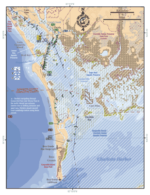
Gasparilla Sound, Placida, and Boca Grande:
This map shows the coastal waters from the southern tip of Manasota Key south to Boca Grande Pass. Included in this map are Don Pedro Island State Park, Charlotte Harbor Preserve State Park, Gasparilla Island State Park, Cape Haze Aquatic Preserve, and Gasparilla County-Charlotte Harbor Aquatic Preserve. This map also shows the locations of two public access boat ramps, five marinas; one with pump out facilities, and four fishing piers.
PDF, 1.32 MB
|
|
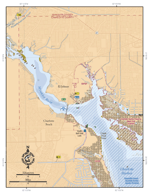
Myakka River and El Jobean:
This map shows the coastal waters from Hog Island to the Sarasota/Charlotte county line, including a small portion of the Myakkahatchee River. Included in this map are El Jobean, Charlotte Beach and South Gulf Cove Lock. This map also shows the locations of three public access boat ramps, one marina and one fishing pier.
PDF, 1.18 MB
|
|
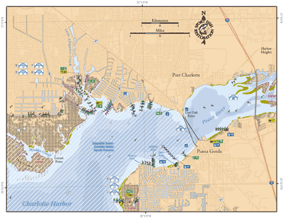
Port Charlotte, Punta Gorda and Peace River:
This map shows the coastal waters from Hog Island to the I-75 bridge over the Peace River. Included in this map are Port Charlotte, Punta Gorda, Gasparilla-Sound-Charlotte Harbor Aquatic Preserve and Charlotte Harbor Preserve State Park. This map also shows the locations of five public access boat ramps, seven fishing piers, and two marinas.
PDF, 1.2 MB
|
|
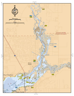
Peace River:
This map shows the coastal waters of the Peace River from the US-41 bridges to near Fort Ogden. Included in this map are Port Charlotte, Punta Gorda, and Charlotte Harbor Preserve State Park. This map also shows the locations of five public access boat ramps, three marinas and one fishing pier.
PDF, 1.06 MB
|
If you have any questions, comments, or suggestions about this Web site, please e-mail us at Boating_Guides@MyFWC.com.
Would you like to receive notices of changes to this Web site and the Boating and Angling Guide to Charlotte Harbor? If so, please e-mail us and include SUBSCRIBE-CHARLOTTE in the subject line. |