CONTACT US:
Florida Fish and Wildlife
Conservation Commission
Fish and Wildlife
Research Institute
100 Eighth Avenue SE
St. Petersburg, Florida 33701
727-896-8626
|
|
|
Mote Marine Laboratory
Tropical Research Laboratory
24244 Overseas Hwy.
Summerland Key, FL 33042
305-745-2729
|
|
|

|
|
This project was funded in part by a grant awarded from Mote Marine Laboratory's Protect Our Reefs Grants Program, which is funded by proceeds from the sale of the Protect Our Reefs specialty license plate. Learn more at .
|
|
|
Additional funding for this project was obtained through the Federal Aid in Sport Fish Restoration Fund.
|
|
|
 |
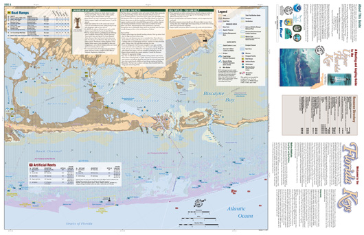
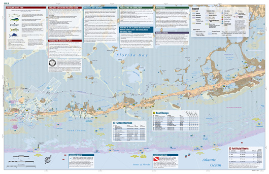
The maps of the Boating and Angling Guides to the Upper, Middle, and Lower Keys have proved to be valuable resources for boaters and anglers, as well as teachers, students, and even oil spill responders (these Guides were used as planning toola during the 2010 Deepwater Horizon oil spill.)
The Maps section of this Web site provides the Boating and Angling Guides to the Upper, Middle, and Lower Keys in various formats. On this page, full-sized copies (22-inches by 34-inches) of the three Guides are available below for you to download and view on your computer.
On the Interactive Maps page, both sides of each Boating and Angling Guide are provided in a format that will allow you to zoom-in and –out and move around the map. Page-sized maps of popular recreation areas are provided on the Detailed Maps page. Maps of boating regulations zones are available on the Marine Zones page.
The maps included on this Web site should not be used for navigation. For local navigation, boater's should consult NOAA Charts 11441, 11442, 11445, 11446, 11447, 11452, 11453, 11462, 11463 and 11464. For more information about NOAA Nautical Charts, please visit NOAA's Office of Coast Survey.
|
FULL-SIZED MAPS
Full-sized copies of each Boating and Angling Guide in PDF format are available below for you to download and view on your computer. Each side of the guide measures 22-inches by 34-inches.
To view these maps you will need Adobe Reader. If you do not have Adobe reader, a copy of this free software can be downloaded from Adobe's Web site.
|
|
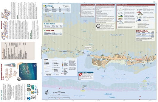
Boating and Angling Guide to the Upper Keys, Side A (PDF, 11.8 MB) - North Key Largo from US-1/Card Sound Rd. split to Old Rhodes Key, including Blackwater Sound, Card Sound, and Biscyane Bay. Also shown are Carysfort Reef, the Elbow, Turtle Rocks, and North Dry Rocks.
|
|
|
Boating and Angling Guide to the Upper Keys, Side B (PDF, 14.2 MB) - Upper Matecumbe to Key Largo at US-1/Card Sound Rd. split, including Islamorada, Plantation Key, Tavernier, and Key Largo. Grecian Rocks, French Reef, Molasses Reef, Conch Reef, and Alligator Reef are also shown.
|
|
|
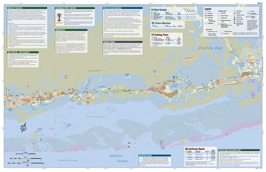
Boating and Angling Guide to the Middle Keys, Side A (PDF, 10.9 MB) - Little Duck Key to Grassy Key, including Marathon,Key Colony Beach, Sombrero Reef, and Coffins Patch.
|
|
|
Boating and Angling Guide to the Middle Keys, Side B (PDF, 12.3 MB) - Key Colony Beach to Lower Matecumbe, including Marathon, Key Colony Beach, Duck Key, and Long Key. Also shown are Coffins Patch and Tennessee Reef.
|
|
|
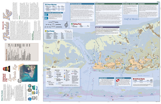
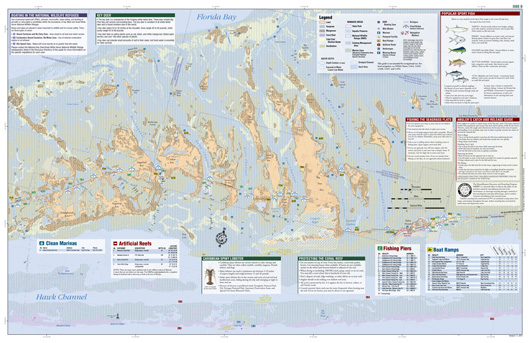
Boating and Angling Guide to the Lower Keys, Side A (PDF, 10.8 MB) - Eastern Marquesas Keys to Bog Coppitt Key. Shown here are Key West; Stock Island; Boca Chica; Eastern and Western Dry Rocks; Sand Key; Eastern, Middle, and Western Sambo;and Pelican Shoal.
|
|
|
Boating and Angling Guide to the Lower Keys, Side B (PDF, 14.0 MB) - Shark Key to Little Duck Key. Map covers Saddlebuch Keys, Sugarloaf Key, Cudjoe Key, Summerland Key, Ramrod Key, Big Pine Key, and Bahia Honda Key are shown in addtion to Looe Key, American and Maryland Shoals, and West Washerwoman.
|
|
If you are out snorkeling, diving, fishing, paddling, or boating and see anything that may be unusual or out of the ordinary (including lionfish) in the waters around the Keys , please record the location, date, and time, and contact the Marine Ecosystem Event Response and Assessment (MEERA) project. They can be reached by phone (305-395-8730), e-mail, or online.
If you have any questions, comments, or suggestions about this Web site, please e-mail us at Boating_Guides@MyFWC.com.
Would you like to receive notices of changes to this Web site and the Boating and Angling Guides to the Upper, Middle, or Lower Keys? If so, please e-mail us and include SUBSCRIBE-KEYS in the subject line.
|