CONTACT US:
Florida Fish and Wildlife
Conservation Commission
Fish and Wildlife
Research Institute
100 Eighth Avenue SE
St. Petersburg, Florida 33701
727-896-8626
|
|
|
Tampa Bay Estuary Program
100 Eighth Avenue SE
St. Petersburg, Florida 33701
727-893-2765
|
|
|
|
|
Funding for this project was obtained through Tampa Bay Estuary Program specialty license plate funds.
|
|
|
Additional funding for this project was obtained through the Federal Aid in Sport Fish Restoration Fund.
|
|
|
 |
Only a small number of the boating regulatory zones in the Tampa Bay area are shown on the maps below. Please look out for posted signs and follow instructions. When in doubt, slow down.
The maps were designed for speedy download to you computer, ability to view on screen, and print on your desktop printer.
To download a copy to your computer, place your cursor over the image, click your right mouse button, then click the "Save Link As" option. After a dialogue box appears, you can select the destination of where you want the image downloaded and, if you choose, a new name for the file. Then click "Save" .
Adobe Reader is needed to view the maps below. If you do not have Adobe Reader, a copy can be downloaded from Adobe's Web site.
|
(PDF, 954 KB)
|
(PDF, 1 MB)
|
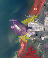
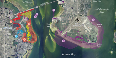
Port Manatee: Shown are security and safety zones around Manbirtee Key, seagrass restoration areas around Port Manatee, and Hillsborough County manatee speed zones.
|
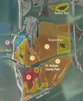
Tierra Verde/Fort De Soto: Boating zones for the Tierra Verde area, Fort De Soto County Park, and Shell Key Preserve are shown here.
|
(PDF, 1.1 MB)
|
(PDF, 1.25 MB)
|
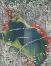
Old Tampa Bay: Pictured here are security and safety zones around Bartow Power Plant and Port Tampa, Fish and Wildlife Commission and U.S. Fish and Wildlife Service manatee speed zones, and boating zones around Weedon Island.
|
Eastern Tampa Bay: Map shows security and safety zones around MacDill Air Force Base (AFB), Big Bend Power Plant, and Manbirtee Key; Hillsborough County, Fish and Wildlife Commission, and US Fish and Wildlife Service manatee speed zones; and seagrass restoration areas around Port Manatee.
|
|
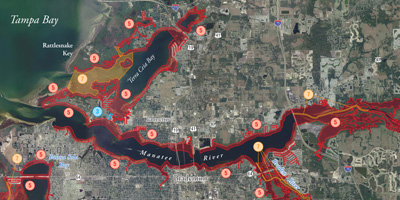
Manatee River and Terra Ceia Aquatic Preserve: Shown here are Fish and Wildlife Conservation manatee speed zones.
|
|
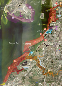
Weedon Island and MacDill AFB: Security and safety zones for Weedon Island, Port Tampa, and MacDill
; U.S. Fish and Wildlife Service manatee zones; and Pinellas County boating zones are shown on this map.
|
(PDF, 1.4 MB)
|
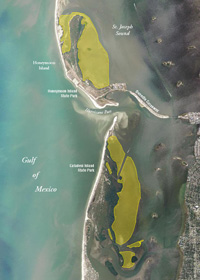
Honeymoon Island and Caladesi Island: Combustion engine exclusion zones on the east side of Honeymoon Island and Caladesi Island State Parks are shown on this map.
|
|
If you have any questions, comments, or suggestions about this Web site, please e-mail us at Boating_Guides@MyFWC.com.
Would you like to receive notices of changes to this Web site and the Boating and Angling Guide to Tampa Bay? If so, please e-mail us and include SUBSCRIBE-TAMPA in the subject line.
|