CONTACT US:
Florida Fish and Wildlife
Conservation Commission
Fish and Wildlife
Research Institute
100 Eighth Avenue SE
St. Petersburg, Florida 33701
727-896-8626
|
|
|
Mote Marine Laboratory
Tropical Research Laboratory
24244 Overseas Hwy.
Summerland Key, FL 33042
305-745-2729
|
|
|
|
|
This project was funded in part by a grant awarded from Mote Marine Laboratory's Protect Our Reefs Grants Program, which is funded by proceeds from the sale of the Protect Our Reefs specialty license plate. Learn more at .
|
|
|
Additional funding for this project was obtained through the Federal Aid in Sport Fish Restoration Fund.
|
|
|
 |
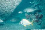
Artificial reefs are man-made habitats that serve to increase reef fish habitat and enhance fishing and diving opportunities. These man-made habitats vary from reef to reef. Some reefs are composed of concrete reefballs of varying sizes, bridge rubble, and old boats and retired military hardware (cleaned in accordance with Florida law). Once deployed, marine life starts colonizing the new habitat. As the reef ages and gets encrusted with algaes, barnacles, and corals, small fish colonize the reef, thus attracting larger predatory fish such as grouper and amberjack.
|
|
Below is a list of artificial reefs found on the Boating and Angling Guides to the Lower Keys, Middle Keys, and Upper Keys. The number identifying each reef is the same as the identifying number used in the Boating and Angling Guides to the Upper, Middle, and Lower Keys.
There are many more artificial reefs in the offshore waters of Monroe and Miami-Dade counties that are not listed here or shown on the boating guide. For a complete listing of artificial reefs in this areas, as well as the rest of Florida, visit FWC's Division of Marine Fisheries, Artificial Reef Program.
|
| No. Reef Name |
Description |
Depth (ft) |
Latitude
Longitude |
|
* - Not shown on printed guides
|
| 1. Stargazer Reef |
Steel structures |
13 |
24° 227.3' N
81° 52.0' W |
| 2. Joe's Tug |
90' Steel tug boat |
65 |
24° 27.85' N
81° 44.27' W |
| Cayman Salvage Master * |
187' Steel ship |
92 |
24° 27.21' N
81° 45.98' W |
| Key West Tournament Reef * |
100' Steel barge |
184 |
24° 27.252' N
81° 46.25' W |
| Key West Tournament Reef * |
260' Steel ship |
180 |
24° 27.25' N
81° 46.25' W |
| Hoyt Vandenberg * |
522' Steel ship |
145 |
24° 27.597' N
81° 44.188' W |
| 3. American Shoal Reef |
Bridge spans and concrete |
42 |
24° 33.119' N
81° 28.018' W |
| 4. Adolphus Busch Sr. |
210' Steel ship |
100 |
24° 31.841' N
81° 27.688' W |
| 5. Bahia Honda Reef |
Bridge spans and concrete |
32 |
24° 35.755' N
81° 17.442' W |
| 6. Seven Mile Bridge Reef |
Bridge spans and concrete |
90 |
24° 36.333' N
81° 10.0' W |
| Big Pine Reef * |
Concrete A-frames |
25 |
24° 33.056' N
81° 19.749' W |
| Big Pine Key Site * |
Concrete A-frames |
18 |
24° 33.016' N
81° 19.498' W |
| Big Pine Key * |
Concrete A-frames |
45 |
24° 32.692' N
81° 19.53' W |
| 7. Seven Mile Bridge Reef |
Bridge spans, concrete |
115 |
24° 34.975' N
81° 9.484' W |
| 8. Thunderbolt |
188' Steel barge |
118 |
24° 39.48' N
80° 57.9' W |
| 9. Marathon Reef Site |
Bridge rubble |
100 |
24° 39.05' N
80° 57.787' W |
| Marathon Reef * |
Bridge spans, Concrete |
115 |
24° 32.917' N
80° 57.451' W |
| 10. Long Key Reefs |
Bridge spans, Concrete |
24 |
24° 43.905' N
80° 49.667' W |
| 11. Long Key Reefs |
Bridge spans, Concrete |
26 |
24° 43.613' N
80° 49.708' W |
| Back to Top |
| 12. Alexander Barge |
120' Steel barge |
95 |
24° 51.7' N
80° 34.1' W |
| 13. Eagle |
287' Steel ship |
110 |
24° 52.18' N
80° 34.21' W |
| 14. Duane |
327' Steel ship |
118 |
24° 59.38' N
80° 22.92' W |
| 15. Bibb |
327' Steel ship |
130 |
24° 29.71' N
80° 22.77' W |
| 16. Spiegel Grove |
510' Steel ship |
135 |
25° 4.0' N
80° 18.65' W |
| Islamorada Reef * |
Bridge spans, concrete |
115 |
24° 50.475' N
80° 33.084' W |
| 17. Alva Chapman Reef |
Concrete boat hulls and dredge pipe |
118 |
25° 17.667' N
80° 9.1' W |
| 18. Doc de Milly |
287' Steel ship |
140 |
25° 22.063' N
80° 7.881' W |
| 19. Berry Patch |
155' Steel ship |
150 |
25° 22.133' N
80° 7.813' W |
| 20. Hugo's April Fool |
115' Steel ship |
145 |
25° 22.027' N
80° 7.823' W |
| 21. Jet Fighters |
3 F-4 Phantom jet fuselages |
118 |
25° 22.05' N
80° 7.616' W |
| 22. Scott Mason-Chaite |
297' Steel ship |
240 |
25° 23.086' N
80° 7.098' W |
| 23. Santa Rita |
200' Steel ship |
245 |
25° 23.251' N
80° 5.54' W |
| 24. Belcher Barge |
85' Steel barge |
120 |
25° 24.775' N
80° 7.146' W |
|
* - Not shown on printed guides
|
| Back to Top |
|
|
|
If you are out snorkeling, diving, fishing, paddling, or boating and see anything that may be unusual or out of the ordinary (including lionfish) in the waters around the Keys , please record the location, date, and time, and contact the Marine Ecosystem Event Response and Assessment (MEERA) project. They can be reached by phone (305-395-8730), e-mail, or online.
If you have any questions, comments, or suggestions about this Web site, please e-mail us at Boating_Guides@MyFWC.com.
Would you like to receive notices of changes to this Web site and the Boating and Angling Guides to the Upper, Middle, or Lower Keys? If so, please e-mail us and include SUBSCRIBE-KEYS in the subject line.
|
|