CONTACT US:
Florida Fish and Wildlife
Conservation Commission
Fish and Wildlife
Conservation Commission
100 Eighth Avenue SE
St. Petersburg, Florida 33701
727-896-8626
|
|
|
Tampa Bay Estuary Program
100 Eighth Avenue SE
St. Petersburg, Florida 33701
727-893-2765
|
|
|
|
|
Funding for this project was obtained through Tampa Bay Estuary Program specialty license plate funds.
|
|
|
Additional funding for this project was obtained through the Federal Aid in Sport Fish Restoration Fund.
|
|
|
 |
This section provides detailed maps for several popular regions of Tampa Bay. These maps provide the same information as, and look like, the printed Boating and Angling Guide to Tampa Bay. The maps were designed for speedy download to you computer, ability to view on screen, and print on your desktop printer.
To download a copy to your computer, place your cursor over the image, click your right mouse button, then click the "Save Link As" option. After a dialogue box appears, you can select the destination of where you want the image downloaded and if you choose, a new name for the file. Then click “Save” .
Adobe Reader is needed to view the maps below. If you do not have Adobe Reader, a copy can be downloaded from Adobe's Web site.
|
|
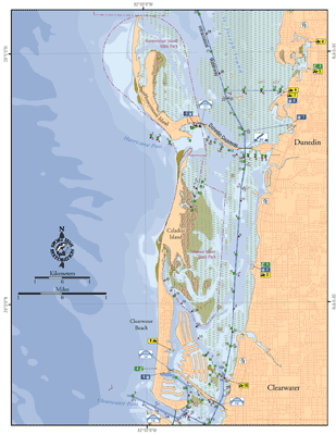
Honeymoon Island, Caladesi Island, and Clearwater Beach:
This map shows the coastal waters from The northern tip of Honeymoon Island south to Clearwater Pass. Included in this map are Honeymoon State Park, Caladesi Island State Park, and Clearwater Beach. This map also shows the locations of seven public access boat ramps, five DEP listed Clean Marinas; four with pump out facilities, and three fishing piers.
PDF, 1.14 MB
|
|
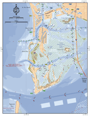
Tierra Verde and Fort De Soto:
This map shows the coastal waters from the Pinellas Bayway south to Egmont Key. Included in this map are Pass-A-Grille, Shell Key, Tierra Verde, and Fort De Soto County Park. This map also shows the locations of four public access boat ramps, three DEP-listed Clean Marinas, and seven fishing piers.
PDF, 1.2 MB
|
|
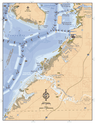
Weedon Island and the Interbay Peninsula:
This map shows the coastal waters from the Gandy Bridge to Shore Arcres, around MacDill Air Force Base to Ballast Point. Included in this map are Weedon Island, Picnic Island, Bayou Grande, and Braden River. This map also shows the locations of seven public access boat ramps, three fishing piers, and two DEP-listed Clean Marinas with pump out facilities.
PDF, 1.65 MB
|
|
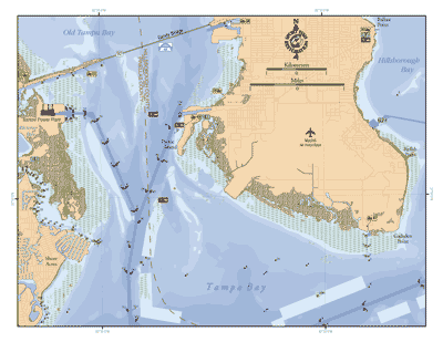
Interbay and East Tampa Bay:
This map shows the coastal waters around the Interbay Peninsula from Picnic Island to Redfish Point, as well as the eatern shore of Tampa Bay from the Alafia River to Port Manatee. Included in this map are MacDill Air Force Base, Apollo Beach, Little Manatee River, E. G. Simmons Park, and Cockroach Bay. This map also shows the locations of ten public access boat ramps and four fishing piers.
PDF, 2.15 MB
|
|
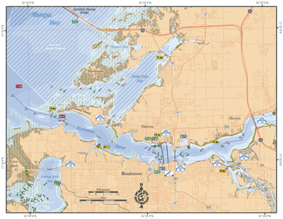
Manatee River and Terra Ceia Bay:
This map shows the coastal waters from the Sunshine Skyway Bridge to Palma Sola Bay. Included in this map are Miguel Bay, Terra Ceia Bay, Manatee River, and Braden River. This map also shows the locations of seven public access boat ramps, three DEP-listed Clean Marinas; two have pump out facilities, and four fishing piers.
PDF, 1.37 MB
|
If you have any questions, comments, or suggestions about this Web site, please e-mail us at Boating_Guides@MyFWC.com.
Would you like to receive notices of changes to this Web site and the Boating and Angling Guide to Tampa Bay? If so, please e-mail us and include SUBSCRIBE-TAMPA in the subject line. |