CONTACT US:
Florida Fish and Wildlife
Conservation Commission
Fish and Wildlife
Research Institute
100 Eighth Avenue SE
St. Petersburg, Florida 33701
727-896-8626
|
|
|
Charlotte County
UF/IFAS Extension
Florida Sea Grant
25550 Harbor View Rd #3
Port Charlotte, Florida 33980
941-764-4340
|
|
|

|
|
Funding for this project was obtained through grants from the West Coast Inland Navigation District and Charlotte County.
|
|
|
Additional funding for this project was obtained through the Federal Aid in Sport Fish Restoration Fund.
|
|
|
 |
The maps of the Boating and Angling Guide to Charlotte Harbor have proved to be valuable resources for boaters and anglers, as well as teachers, students, and even oil spill responders (the Boating and Angling Guide to Charlotte Harbor was used as a planning tool during the 2010 Deepwater Horizon oil spill.)
The Maps section of this Web site provides the Boating and Angling Guide to Charlotte Harbor in various formats. On this page, full-sized copies (22-inches by 34-inches) of the guide are available for you to download and view on your computer.
On the Interactive Maps page, both sides of the guide are provided in a format that will allow you to zoom-in and zoom-out and move around the map. Page-sized maps of popular recreation areas are provided on the Detailed Maps page. Maps of boating regulations zones are available on the Marine Zones page.
The maps included on this Web site should not be used for navigation. For local navigation, boater's should consult NOAA Charts 11424, 11425, and 11426. For more information about NOAA Nautical Charts, please visit NOAA's Office of Coast Survey.
|
FULL-SIZED MAPS
Full-sized copies of the guide in PDF format are available below for you to download and view on your computer. Each side of the guide measures 22-inches by 34-inches.
To view these maps you will need Adobe Reader. If you do not have Adobe Reader, a copy of this free software can be downloaded from Adobe's Web site.
|
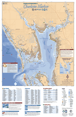
Map Side, PDF, 1.83 MB
|
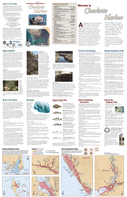
Text Side, PDF, 13 MB
|
|
If you have any questions, comments, or suggestions about this Web site, please e-mail us at Boating_Guides@MyFWC.com.
Would you like to receive notices of changes to this Web site and the Boating and Angling Guide to Charlotte Harbor? If so, please e-mail us and include SUBSCRIBE-CHARLOTTE in the subject line.
|