CONTACT US:
Florida Fish and Wildlife
Conservation Commission
Fish and Wildlife
Research Institute
100 Eighth Avenue SE
St. Petersburg, Florida 33701
727-896-8626
|
|
|
Mote Marine Laboratory
Tropical Research Laboratory
24244 Overseas Hwy.
Summerland Key, FL 33042
305-745-2729
|
|
|
|
|
This project was funded in part by a grant awarded from Mote Marine Laboratory's Protect Our Reefs Grants Program, which is funded by proceeds from the sale of the Protect Our Reefs specialty license plate. Learn more at .
|
|
|
Additional funding for this project was obtained through the Federal Aid in Sport Fish Restoration Fund.
|
|
|
 |
This section provides detailed maps for several popular regions of the Florida. These maps provide the same information as, and look like, the printed Boating and Angling Guides to the Upper, Middle, and Lower Keys. The maps were designed for speedy download to you computer, ability to view on screen, and print on your desktop printer.
To download a copy to your computer, place your cursor over the image, click your right mouse button, then click the "Save Link As" option. After a dialogue box appears, you can select the destination of where you want the image downloaded to and if you choose, a new name for the file. Then click “Save.” .
Adobe Reader is needed to view the maps below. If you do not have Adobe Reader, a copy can be downloaded from Adobe's Web site.
|
|
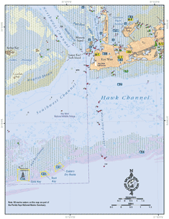
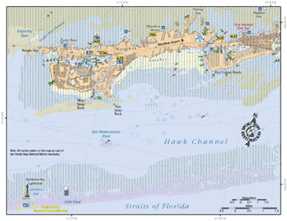
Key West:
This map shows the coastal waters from the eastern Marquesas to Stock Island (MM 0-5). Included in this map are Key West, Sand Key,Rock Key and Eastern Dry Rocks. This map also shows the locations of five public access boat ramps, three DEP listed Clean Marinas, and one fishing piers.
PDF, 1.04 MB
|
|
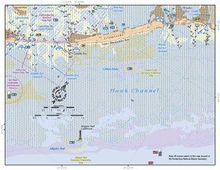
Marathon:
This map shows the coastal waters from Knight Key to Fat Deer Key, including Marathon and Key Colony Beach (MM 46-56). Included in this map are Boot Key Harbor and Sombrero Key. This map also shows the locations of six public access boat ramps, two DEP-listed Clean Marinas, and one fishing pier.
PDF, 932 KB
|
|
Upper Matecumbe and Islamorada:
This map shows the coastal waters off Upper Matecumbe (MM 77-86), including Lingunvitae Key, Islamorada, Alligator Reef, and Cheeca Rocks. This map also shows the locations of two public access boat ramps and two DEP-listed Clean Marinas.
PDF, 866 KB
|
|
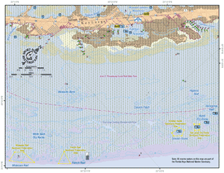
Key Largo:
This map shows the coastal waters off Key Largo (MM 98-101). Included in this map are Largo Sound, Molasses Reef, French Reef, Grecian Rocks, and Key Largo Dry Rocks. Also shown is John Pennekamp Coral Reef State Park and Key Largo Existing Management Area. This map shows the locations of two public access boat ramps and one DEP-listed Clean Marina.
PDF, 1.49 MB
|
|
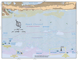
Key Largo and Carysfort Reef:
This map shows the coastal waters off Key Largo from North Dry Rocks to North Carysfort Reef. Included in this map are John Pennekamp Coral Reef State Park, The Elbow, South Carysfort Reef, and Carysfort Reef. This map does not show any boat ramps or DEP-listed Clean Marinas. The closest boat ramp and Clean Marina to this map extent is John Pennekamp Coral Reef State Park.
PDF, 862 KB
|
|
|
If you are out snorkeling, diving, fishing, paddling, or boating and see anything that may be unusual or out of the ordinary (including lionfish) in the waters around the Keys , please record the location, date, and time, and contact the Marine Ecosystem Event Response and Assessment (MEERA) project. They can be reached by phone (305-395-8730), e-mail, or online.
If you have any questions, comments, or suggestions about this Web site, please e-mail us at Boating_Guides@MyFWC.com.
Would you like to receive notices of changes to this Web site and the Boating and Angling Guides to the Upper, Middle, or Lower Keys? If so, please e-mail us and include SUBSCRIBE-KEYS in the subject line. |