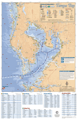
The Maps section of this Web site provides the Boating and Angling Guide to Tampa Bay in various formats. On the Interactive Maps page, both sides of the guide are provided in a format that will allow you to zoom-in and –out and move around the map. An online map with detailed information about ramps, piers, Clean Marinas, artificial reefs, bridges and fishing hot spots can be found on the Online Map (External Web page). Individual maps of popular recreation areas are provided on the Detailed Maps page (Not optimized for mobile). Maps of boating regulations zones are available on the Marine Zones page (Not optimized for mobile).
Funding for this project was obtained through Tampa Bay Estuary Program specialty license plate funds.