CONTACT US:
Florida Fish and Wildlife
Conservation Commission
Fish and Wildlife
Research Institute
100 Eighth Avenue SE
St. Petersburg, Florida 33701
727-896-8626
|
|
|
City of Jacksonville
Parks and Recreation
214 N. Hogan Street
Third Floor
Jacksonville, Florida
32202
904-630-2489
|
|
|


|
|
This project was funded in part by a grant awarded by the and .
|
|
|
Additional funding for this project was obtained through the .
|
|
|
 |
Only a small number of the boating regulatory zones in the St. Johns and St. Marys Rivers are shown on the maps below. Please look out for posted signs and follow instructions. When in doubt, slow down.
To download a copy to your computer, place your cursor over the image, click your right mouse button, and then click the "Save Link As" option. After a dialog box appears, you can select the destination of where you want the image downloaded to and if you choose, select a new name for the file. Then click "Save."
Adobe Reader is needed to view the maps below. If you do not have Adobe Reader, a copy can be downloaded from Adobe's Web site.
|
(PDF, 1.91 MB)
|
(PDF, 2.27 MB)
|
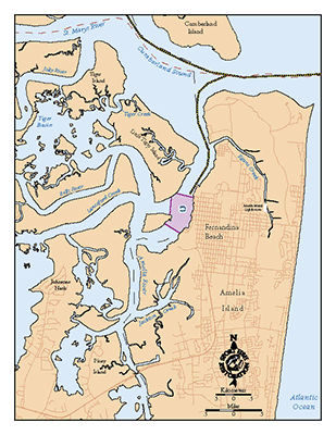
St. Marys River/Fernandina Beach: Shown are a moving security zone for the St. Marys and Amelia rivers, as well as an idle speed zone at Fernandina Beach.
|
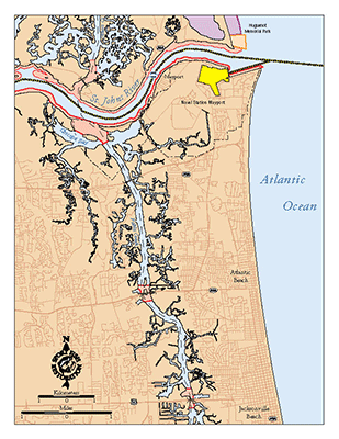
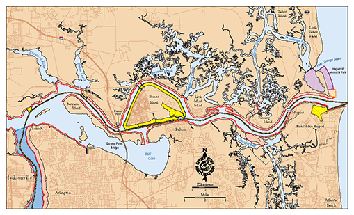
Pablo Creek/ Mouth of St. Johns River: A moving security zone for the St. Johns River, a security zone for NS Mayport, manatee speed zones for the St. Johns River, and boating safety zones on the San Pablo River are shown on this map.
|
(PDF, 2.21 MB)
|
(PDF, 2.46 MB)
|
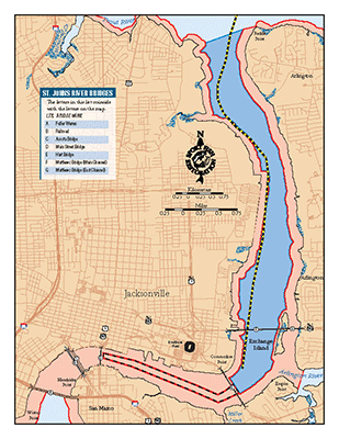
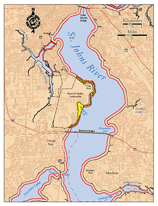
Port of Jacksonville/Downtown Jacksonville: This maps shows manatee speed zones and a moving security zone for the St. Johns River from Reddie Point to the Fuller Warren Bridge.
|
Upper St. Johns River: Boaters can find manatee speed zones and a security zone (NAS JAcksonville) in this area.
|
(PDF, 2.94 MB)
|
Lower St. Johns River: This map shows the following zones from the Port of Jacksonville to the mouth of the St. Johns River: security zones (moving, conditional, and permanent), manatee speed zones, and local boating zones (Huguenot Memorial Park). NOTE: This map should be printed on legal-sized paper.
|
|
If you have any questions, comments, or suggestions about this Web site, please e-mail us at Boating_Guides@MyFWC.com.
Would you like to receive notices of changes to this Web site and the Boating and Angling Guide to Nassau and Duval Counties? If so, please e-mail us and include SUBSCRIBE-DUVAL in the subject line.
|